Home
 About ITFC
Impacts
and Achievements
Completed MSc and
PhD projects
About ITFC
Impacts
and Achievements
Completed MSc and
PhD projects
|
A study of land
cover change in
Bwindi Impenetrable
National Park (BINP),
Uganda using
satellite imagery
analysis. Ian Lacey,
MSc thesis 2009 |
|
The
transformation of tropical forests for agricultural land and extractive
resource use will be one of the most serious threats to sub-Saharan
forest cover during the 21st century. This study used
satellite imagery over a period of 18 years (1987-2005) to analyse the
level and extent of land cover change in and around Bwindi Impenetrable
National Park (BINP). Focus group discussions were conducted with local
communities adjacent to the park to explore their perceptions on land
cover change, the drivers behind it and benefit sharing programmes aimed
at limiting anthropogenic impacts on the forest.
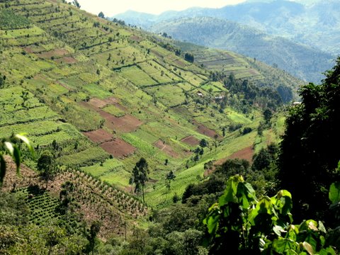
The
results of analysis of satellite images over an 18 year period show that
forest cover in the region of BINP has decreased by 9.8%. This
deforestation has mainly taken place in the remaining forest fragments
outside the national park. The high population density and rapid growth
in the districts surrounding BINP is identified as the major underlying
driver of the land cover change while the most significant agent of this
change has been the community’s harvesting of timber for building
materials and firewood. Although the benefit sharing programme of
Multiple Use Zones (MUZs) has helped ease pressures on the forest and
its resources, it needs to be updated in the coming years to maintain
people’s interest. This should also be coupled with a scheme to
encourage development of communal woodlots and alternative energy
sources to reduce potential demands on the forest in future years. |
|
|
|